|
|
|
FEATURE STORY
Page 4
Simon Owen
HRVG INTERMEDIATE PRODUCT REPORT #010907
By Dick Allgire
LOCATION
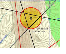
PRIMARY LOCATION N 21� 20.852� W 157� 47.152
The primary location of interest is a triangular area of 800 feet by 786 feet by 768 feet, in steep terrain from 1500 feet rising to 2000 feet in the vicinity of the upper ravine that forms the beginning of Maunawili Stream.
[see map 1 Overview]
[see map 2 Primary Location]
Recommendations:
If possible search the primary location area, in addition to a search of the area directly below the primary location. Over the recent years with time, wind, rain, the natural draw of the terrain, and gravity surely residue from any physical remains in this area would be washed down to the upper portion of Maunawili Stream.
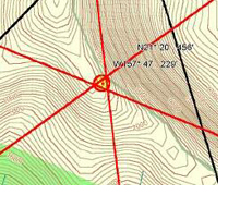
SECONDARY LOCATION N 21� 20.456� W 157� 47.229
The secondary location is a triangular area 100 feet by 122 feet by 129 feet located near the top of the ridge at N 21� 20.456� W 157� 47.229. This a very small area and it is on the windward side of the ridgeline.
[see map 3 Secondary Location]
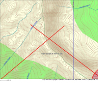
TERTIARY LOCATION N 21� 20.556� W 157� 47.239
The tertiary location is a point at 2024 feet elevation. This location is approximately 566 feet from the secondary location on an azimuth of 338� magnetic from the secondary location and is radical vertical terrain.
[see map 4 Tertiary Location]
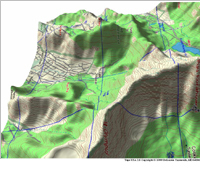
We have provided a 3-dimensional overview of the area for reference.
[see map 5 3-D overview]
[Click on images to see larger version.]
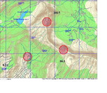
MAP 1, OVERVIEW
The red circles indicate encrypted reference locations. Viewers determined direction to target from these known locations.)
MAP 2, PRIMARY LOCATION
MAP 3, SECONDARY LOCATION
MAP 4, TERTIARY LOCATION
MAP 5, 3-D OVERVIEW
ANALYTICAL DETERMINATIONS
As the analyst of this project, my recommendation is that the primary, secondary and tertiary locations are probable areas for the remains of Simon Owen. At a minimum analysis reveals a high possibility that Simon fell to the north of the ridgeline making location of remains on the windward side of the ridge probable.
If this case continues to remain unresolved additional information can be obtained by the Hawaii Remote Viewers� Guild at a later date.
W9M7-G9Q4 DATA EXTRACTION
W9M7-G9Q4 WORKING NOTES
· There is a single human at this target, probably a male.
· The smell of sweat and human body odor is probably associated with this target.
· There is vegetation present at the target, possibly forest with trees, including palms and ferns.
· There is land at the target that is steep, sloping, and peaked.
· The terrain at this target is rocky.
· There is strong blowing wind present at the target.
· There is possible a trail or pathway present at the target.
· A shuffling sound may be present at this target.
· There is a thumping/thudding sound associated with the target.
· There may be a person on a ledge at the target.
· There is downward tumbling movement associated with this target.
· There is probably blood present at the target.
· There is an injured human, possibly with contusions, lacerations and head trauma at the target.
· A smell of decay and rotting is present at the target.
· There is a dead body at the target.
SCENARIO
A man is alone on a trail in steep rugged terrain surrounded by forest and vegetation. The man falls and tumbles down a steep incline, and suffers fatal injuries. 
 PRINT THIS ARTICLE PRINT THIS ARTICLE
Privacy Statement
Copyright © 2002, H.R.V.G.
All rights reserved. |
|
|

JULY-AUGUST ARTICLES
·Simon Owen Report
Page 2
Page 3
Page 4
Data Extraction
·2002 IRVA Conference
·Conference Photos
Page 1
Page 2
Page 3
Page 4
Photo Register
·Near Future Event
Session Data
·Cy Shinkawa
·Remote Viewing
·PJ Gaenir
Page 2
·Discussions on RV |