Where is the the Mars Polar Lander Crash Site Located?

BACKGROUND
The Mars Polar Lander was launched from earth on January 3, 1999. The lander was scheduled to touch down on the red planet on December 3, 1999. The purpose of the mission was to search for ice, study the Martian atmosphere, and search for evidence of ancient climates.
The landing site was to be a rectangular area 200 kilometers (125 miles) long and 20 kilometers (12-1/2 miles) wide, a swath of terrain measuring about 4,000 square kilometers (1,500 square miles) at the Martian South Pole. The coordinates of the site are 76S, 195W.
NASA lost contact with the lander on December 3, 1999. According to NASA, flight controllers are continuing to work through their fault-tree scenarios in their ongoing attempts to communicate with the spacecraft. They say the chances of recovering the lander remain remote.
Team members plan to continue looking for a signal from the lander through mid-January, and at that point they will be in a position of having exhausted all possible recovery modes.
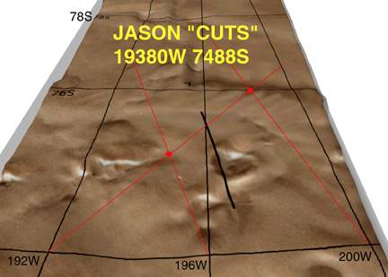
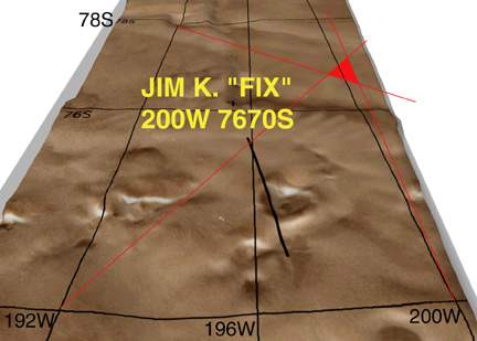
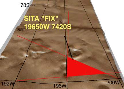
On Friday December 10 members of the Hawaii Remote Viewers Guild were assigned the location of the Mars Polar Lander as an in-class operational target. The target was worked blind; viewers were told nothing of the nature of the target. They were not told it involved the mission spacecraft, they were not told the target was on Mars. Viewers were given a random alpha-numeric ID: I5O6-U3B4. This ID represented the target cue MARS LANDER/ CRASH SITE/ NEAR PAST. They were further given random number combinations cued to latitude and longitude coordinates on Mars.
The viewers executed protocols known as S-7 Annex A, producing directional ideograms from coded locations. The viewers then used protractors to calculate azimuths and determine lines of bearing. All viewers identified locations close to the proposed landing site, which in itself is rather amazing, given their azimuths could have intersected anywhere on the entire planet.
What is S-7 Annex A?

S-7 Annex A is a remote viewing protocol designed to determine location. It involves the execution of spontaneous directional ideograms.
Human subconscious awareness can determine the direction to target from a known location without the primary consciousness knowing the target or the encoded baseline locations.
Studies have demonstrated that blindfolded subjects, disoriented and driven to remote locations, have the ability to intuitively point in the direction of home.
After producing monitored directional iIdeograms, viewers and analysts use protractors to determine azimuths to target. The bearings are adjusted for perspective and magnetic deviation and plotted on a map. The intersection of three lines is called a FIX and two lines intersection is called a CUT.
VIEWER SESSION DATA


CONCLUSION
In late December, NASA’s orbiting Mars Global Surveyor spacecraft began an imaging campaign to look for evidence of the lander, parachute or aeroshell. (There may be 3 separate parts of the lander at different locations on Mars.)
Hopefully the Mars Surveyor will locate the parachute and/or parts of the Mars Polar Lander, thus providing feedback for this remote viewing project. We will update this project as data becomes available.
For more on the lander see: NASA – Mars Polar Lander